10 years ago
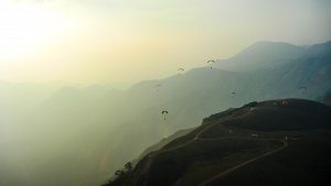
The site at Vagamon is situated at the hills of Kolahalamedu, 4 Kms (2.5 Miles) from Vagamon. This is a part of South India‘s Second highest peak namely the Amruthamedu. There is a 10 km long ridge with 3,000 feet from top to bottom. The site has steady winds in the South West Direction through out the season. The season starts from September and offers great flying conditions until Jan and again, from March to May. Vagamon boasts of cool climate during most part of the year.
The GPS co-ordinates are:
9.38‘ 49.56 ‘‘ North Latitude
76.55‘ 52.92‘‘ East Longitude
Altitude : 1112 Meters 3040.244 Feet (Above Mean Sea Level)
Wind Direction :South West (SW)
This place offers great opportunities for XC as well as ridge soaring. The site is easily accessible, with grassy launch pads.
Nearest airport is three hours drive at Cochin(COK) . Nearest rail road is Kottayam, 65 kms away. There are plenty of buses plying between Vagamon and other parts of Kerala.The spot is near to famous Periyar Tiger Reserve at Thekkady.


Latest Comments
'm so sorry for the late reply Athul!
Check these links to get an idea about Vagamon :
http://www.youtube.com/watch?v=U9hEbn2hb7s&list=PLmIVCbbvqtZfpqAhFYjuUd8...
http://www.youtube.com/watch?v=vOXMHErQk5U&list=PLmIVCbbvqtZfpqAhFYjuUd8...
http://www.youtube.com/watch?v=v4PhmcY4-ao&list=PLmIVCbbvqtZfpqAhFYjuUd8...
or
http://www.youtube.com/playlist?list=PLmIVCbbvqtZfpqAhFYjuUd8L9MlfN_OMA&...
For more details, pictures and videos Follow - www.facebook.com/flyvagamon
i need video of this site my Email a/c is skywalkflyingclub@yahoo.com.